Electromagnetic & Seismic Survey
We develop creative, comprehensive, and sustainable engineering solutions for a future where society can thrive.

About Service
Delivering results, reliability, & rock solid dependability.
We develop creative, comprehensive and sustainable engineering solutions for a future where society can thrive.
Geoteq international offers a wide range of services in Exploration Data Acquisition & Survey, Data Processing, Re-processing and interpretation.
Geoteq International provides technical expertise in Electromagnetic (EM), Seismic, Full Tensor Gradiometry, Surface Geochemical Exploration, Hydrography Survey, Geotechnical Survey and Positioning, Navigation & Offshore Site Survey.
Electromagnetic
- EM data acquisition is available in both Land and Marine
- EM data survey depth range is wide, from 50m to 7000m
- EM primary working principle is based on relationship between resistivity and fluid type change in the reservoirs
EM Applications
- Complements 2D/3D Seismic data and provide additional information such as Resistivity and Induced Polarization (IP)
- EM data can be acquired pre-Seismic and post-Seismic to:
- De-risk prospects
- Guide in planning accurate well placements
- Joint interpretation with Seismic & Well Logs data

Land EM Acquisition

Land EM Acquisition
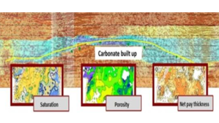
Joint Seismic, Well Logs & EM Interpretation
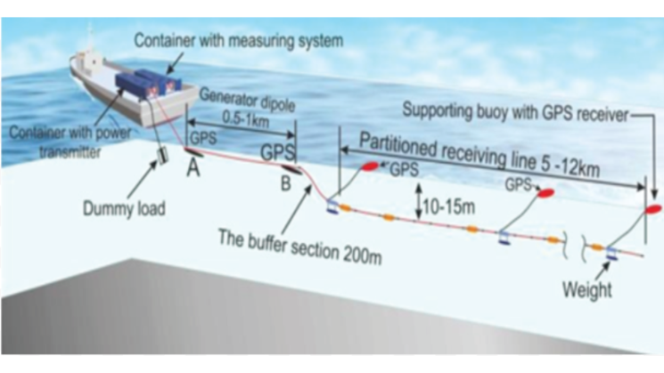
Marine EM Acquisition
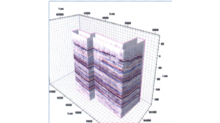
3D Seismic Data
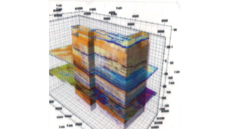
3D Seismic + EM Data
Electromagnetic
- EM data acquisition is available in both Land and Marine
- EM data survey depth range is wide, from 50m to 7000m
- EM primary working principle is based on relationship between resistivity and fluid type change in the reservoirs
EM Applications
- Complements 2D/3D Seismic data and provide additional information such as Resistivity and Induced Polarization (IP)
- EM data can be acquired pre-Seismic and post-Seismic to:
- De-risk prospects
- Guide in planning accurate well placements
- Joint interpretation with Seismic & Well Logs data
SEISMIC
Our Features
Geoteq international offers a wide range of services in Exploration Data Acquisition & Survey, Data Processing, Re-processing and interpretation.

Seismic
- Data Acquisition:
- Land & Marine
- Transition Zone
- Data Processing and Re-processing:
- Near Surface Imaging and Statics Solutions
- 3D VSP & Surface Seismic Visualization
- 2D & 3D Survey Design & Modeling
- Interpretation
Full Tensor Gradiometry, FTG (Airborne)
- Acquire quality gravity data
- Provide advanced data processing & interpretation
Hydrography (Bathymetry) Survey
- Robust acquisition devices – Multi-Beam Echo Sounder and Side Scan Sonar
Geotechnical Survey
- Combination of shallow geophysical methods:
- Shallow Transient Electromagnetic
- Ground Penetrating Radar
- Applications include shallow hazards investigation
Positioning , Navigation & Offshore Site Survey
- Position offshore facilities such as ROVs
- Marine navigation & hydrographic projects
- Surveying seabed for pipeline installation
Surface Geochemical Exploration
- Reduce exploration risk by identifying prospects with greatest petroleum potential
- Applicable in:
- Frontier Basin Evaluation
- By-passed pay in mature fields